
Talisayi Fm
Type Locality and Naming
Western Tianshan. The Talisayi Fm was named by Wang Jingbin in 1982. The type section is located at Talisayi valley along the highway from Urumqi to Yining in area of Guozigou, Huocheng County, Xinjiang Weiwuerzhu Zizhiqu (Xinjiang Uygur Autonomous Region) (Wang Jingbin, 1982, 1985). Coordinate: 44°28′10.5"N; 81°07′23.2"E. Uppermost formation (6 of 6) of Kiaketi Gr).
Synonym: (塔里萨伊组)
Lithology and Thickness
The Talisayi Fm consists of gray massive unstratified and unsorted tillite, muddy gravel (diamictite) interbedded with gray-green and gray-black or minor purple-red siltstone and silty shale. The horizon and thickness of massive tillite is not stable, with a single bed 10-175 m thick. There are four beds of tillite in Guozigou area, and five beds of tillite in Aheqiat area, but one bed in Tarqiat area. This section consists mainly of silty mudstone and siltstone. The thickness of the tillite changes a lot, and a part or whole formation was denuded later. The thickness of the tillite changes from 0 to 424 m; Usually, the thickness is over 100 m west of Aheqiat.
Relationships and Distribution
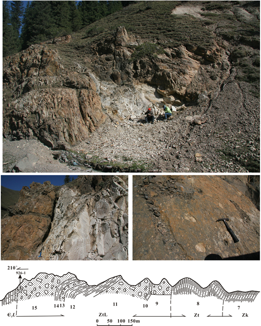
Lower contact
The Talisayi Fm is conformable onto the underlying Tarqiate Fm.
Upper contact
It disconformably underlies the overlying Lower Cambrian Linkuanggou Fm. There is a weathering crust at the boundary between the Talisayi Fm and Linkuanggou Fm, which is tens of centimeters to 1.5 m in thickness, with the rock color transformed from gray to bright yellow.
[Figure: The boundary between Talisayi Fm and Cambrian Linkuanggou Fm in Guozigou valley, Xinjiang]
Regional extent
Western Tianshan. Huocheng County, Xinjiang Weiwuerzhu Zizhiqu (Xinjiang Uygur Autonomous Region). The Talisayi Formation is mainly exposed in Guozigou, northeast of Yining County and in Talisayi and Aheqiat area in northern slope of Kokirqin Mountains. Eastwards to the residential area of Kokirqin, this whole formation is denuded.
GeoJSON
Fossils
Microplants have been found in argillaceous siltstone, such as Trachysphaeridium incrassatum, Trematosphaeridium holtedahlii, Microconcentrica sp., Leiopsophosphaera solida, Polyporata microporosa, Taeniatum sp. etc.
Age
Depositional setting
Additional Information
A whole rock Rb-Sr isochron date (640±33 Ma) had been acquired from a carbonaceous bed in silty shale (Zhu Jiechen, 1985). SHRIMP U-Pb data of 642±5 Ma had been obtained from a granite intruded into the top part of the formation just below the Cambrian Linkuanggou Fm (Gao Wei at al., 2011).